


The World on a Sheet. Comparative Tables of Mountains and Rivers in 19th-Century Atlases.
Fage| N° d'inventaire | 22268 |
| Format | 30 x 28.5 |
| Détails | 203 p., bound. |
| Publication | Paris, 2014 |
| Etat | Nine |
| ISBN | 9782849753439 |
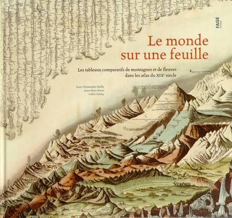
Although representations of mountain profiles have been documented since the Renaissance, it was not until the very end of the 18th century that the first "comparative tables" of data collected by explorers crisscrossing the world appeared: heights of mountains and waterfalls, lengths of rivers, surface areas of lakes or islands, etc. This type of representation, which offers "men who want to see [...] a microcosm on a sheet of paper," to use the words of Humboldt, a pioneer in the field, was to enjoy immense success, and before disappearing at the dawn of the 20th century, it gave rise to a wide variety of astonishing plates combining the refinement of drawing and composition with scientific and didactic concerns. The World on a Sheet is the first work, not only in French but in the whole world, to offer a journey through this rich corpus of "tableaux" dedicated to extraordinary geological phenomena, ranging from austere graphs to fantastic landscapes. Two renowned historians of geography and cartography, Jean-Marc Besse and Gilles Palsky, serve as guides for the reader and analyze the different types of representation adopted by publishers of atlases and "posters" (especially American and European) to organize all the topographical information on a single sheet. It is up to a third author, himself a great lover of maps, the writer Jean-Christophe Bailly, to evoke the power of fascination of these images that seem to be from an imaginary world...
Although representations of mountain profiles have been documented since the Renaissance, it was not until the very end of the 18th century that the first "comparative tables" of data collected by explorers crisscrossing the world appeared: heights of mountains and waterfalls, lengths of rivers, surface areas of lakes or islands, etc. This type of representation, which offers "men who want to see [...] a microcosm on a sheet of paper," to use the words of Humboldt, a pioneer in the field, was to enjoy immense success, and before disappearing at the dawn of the 20th century, it gave rise to a wide variety of astonishing plates combining the refinement of drawing and composition with scientific and didactic concerns. The World on a Sheet is the first work, not only in French but in the whole world, to offer a journey through this rich corpus of "tableaux" dedicated to extraordinary geological phenomena, ranging from austere graphs to fantastic landscapes. Two renowned historians of geography and cartography, Jean-Marc Besse and Gilles Palsky, serve as guides for the reader and analyze the different types of representation adopted by publishers of atlases and "posters" (especially American and European) to organize all the topographical information on a single sheet. It is up to a third author, himself a great lover of maps, the writer Jean-Christophe Bailly, to evoke the power of fascination of these images that seem to be from an imaginary world...